Regions

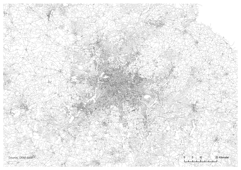
Agglomeration Ruhr
The Agglomeration Ruhr has a polycentric structure without a clear dominant centre. Consisting of numerous cities of different sizes, the Agglomeration Ruhr has no formal administrative unit. As a result there are many interior borders between the different cities. Also typical of the Agglomeration Ruhr is the great number of internal fringes which separate settlement areas. These areas include industrially used areas, areas for storage and logistics, paths of energy supply or one of the regional green belts crossing the region. The building and settlement structure of the Agglomeration Ruhr is the result of a historical process. In only about 100 years an agricultural region turned into a highly productive industrial landscape. A dense network of roads connects smaller and larger cities, each with its own identity. Therefore it was always difficult to regard the region as one, with consistent interests. The interests of the numerous large, medium and small cities are too diverse. The whole region is a mosaic of different areas that fulfill specific functions and represent their own individual interests. Figures illustrate that local governmental structures remain of great importance in the Agglomeration Ruhr. The Area has two Landscape Associations, 20 institutions for economic development, 24 traffic enterprises and 6 chambers. Regardless several achievements in structural change during the last decades, the Agglomeration Ruhr is facing tasks of managing future development towards a socially balanced and economically strong region. The current ‘Regional Discourse’ initiated by the Ruhr Regional Planning Association (RVR) aims at the establishment of a legally binding regional plan until 2020. Therefore all 53 municipalities participate in the discursive creation of the Ruhr Planning Association Assembly and the Ruhr Parliament as the main political powers of the region, and respecting local and regional governance structures. Contentually, it is touching the topics of regional spatial development, especially settlement area, landscape or traffic management, connecting it to further issues such as social and economic cohesion and development of strategic fields of innovation.
Berlin-Brandenburg Metropolitan Region
The Berlin-Brandenburg metropolitan region is one of eleven metropolitan regions in Germany and the second largest agglomeration after the Rhein-Ruhr metropolitan region. It consists of the capital city Berlin and the surrounding area of Brandenburg. Unlike many metropolitan regions, which are polycentric and based on morphological measures, Berlin/Brandenburg region is to a large extent centric. Nevertheless, even under the dominance of Berlin, it follows functional polycentricity and interdependence between cities of the region. Like the most cores of metropolitan regions in Germany, Berlin witnesses population growth and therefore facing the challenges of meeting the demands of new housing projects and social-and-physical infrastructure. Berlin city as an autonomous federal state consists of central city government and city wards. Despite its population growth, the region is facing challenges of maintaining social cohesion and global economic position. In the current years, real investment boom and population growth has resulted into Gentrification, increasing rents and real state costs and Social segregation and peripheralization of poor people. A general task becomes the governance issue: how to participate citizens in strategic plans needed to steer the fast inner urban redevelopment induced by the real estate boom as well as the task to re-establish its federal capital function.
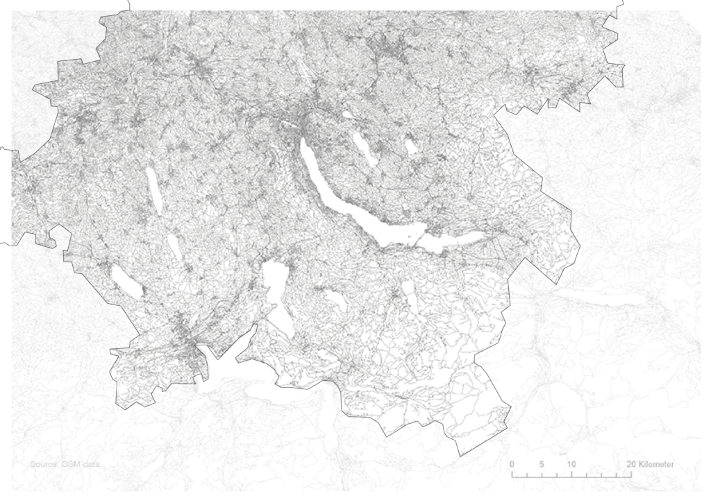
Zurich Metropolitan Area
Zurich metropolitan Area is the largest of three metropolitan areas in Switzerland and one of Europe’s strongest economic centers. It includes the canton of Zurich and a six neighboring regions. The metropolitan region of Zurich follows a morphological and functional polycentric pattern and interconnections including nodes and corridors of development between the regions’ many municipalities. managing spatial development of the booming region within the limited space is one of the main planning challenges in Zurich metropolitan region. It calls for alternative governance polices that incorporate the local, regional and metropolitan dimensions.

Nord Pas de Calais
A cross-border metropolitan region located at the crossroads of key infrastructures for transit of goods, and so linking the major metropolitan areas in North-West Europe (Paris, London, Randstad Holland, the Rhine-Ruhr basin in Germany). Nord Pas de Calais is the fourth most populous region of France nine metropolitan regions. Just like the Ruhr region, Nord-Pas-de-Calais contributed substantially to the mining, steel and textile industrial development until the middle of the 20th century, with many of its coalfields now classified as a UNESCO world heritage sites. Nord-Pas de Calais currently still suffers the consequences of the decline of its industrial history, with net outmigration, a high unemployment rate and enduring social difficulties. The last two decades have witnessed major planning attempts of industrial restructuring and attraction of newer industries based on substantial public investment incentives.
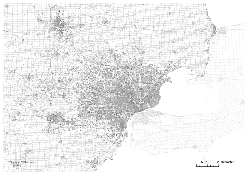
Detroit metropolitan area – Metro Detroit
The greater Detroit metropolitan region is located in the southeast Michigan and has one of the largest spatial footprints for cities of comparable inhabitants’ numbers. In contrast to the classic perpendicular “grid pattern”, the road system that defined Detroit was the alternative “hub-and-spoke” radial net¬work. The region is characterized by significant patterns of spatial economic and social division. While the Detroit city area faces serious economic challenges caused by the car-production based industrial economy decline resulting into public budget difficulties, massive enduring housing vacancies due to inhabitant outflux during the 1960ies and 1970ies and connected societal issues, the wider metro area counts to wealthiest regions in the US. Currently, selective revital¬ization in the central area of Detroit city has produced “bubble urbanism,” reinforcing the already highly uneven urban land¬scape. Innovative planning strategies and long-term planning process are at the head of the aims of the regional planning of Detroit metropolitan area. Strong competition between cities of the region as well as relatively weak regional governmental structures count to the current challenges of endeavor to reestablish evenly the regional stability.

Kansai Metropolitan Area
The Kansai region is the second largest metropolitan region in Japan after the Tokyo metropolitan area. Kansai has long been the political, economical and cultural center of western Japan and the East Asian region until the capital was moved to Tokyo in 1868 and became gradually the concentrated global center. Similarly to the Ruhr region for Germany, Kansai contributed to the prosperity of the modern Japanese industrial state. Beginning with textile production, its central area at the Osaka bay became an industrial centre of the country in the 19th century, followed by steel and chemical production during the first half and the electric machinery industry during the second half of the 20th century. Despite it continued to lose its growth position on Tokyo, the Kansai region remains under the 20 largest regional economies worldwide. Today`s challenge is the stabilization of regional economy through high-tech innovation and the demographic change. The high competition between the regions’ cities and the reaction to the slowing growth leads into individual centralization strategies, leaving peripheral parts of the regional metropolitan area with slower development pace. A task is thus an establishment of regional governmental structures of a regional management for coordination of strategic development tasks.